It has been obvious for some time that ground-based expeditions to Mt. Ararat in search of Noah's Ark have very little chance of succeeding. All who have seen pictures of the mountain and heard of the difficulties and dangers fully understand the necessity of using other methods.
 |
This past August, the Institute for Creation Research (ICR) participated in an international expedition comprised of representatives of four organizations in cooperation with two Turkish companies. This consortium was granted permission by the very cooperative central government in Ankara, (1) to survey and photograph all areas of interest on the mountain from a fixed-wing airplane, (2) to investigate with a high-altitude helicopter any promising sites discovered from the aircraft or aerial photos, and (3) to document any discovery by a ground-based climbing party. As a requirement of this permit, we were asked to do an equivalent study of the boat-shaped formation some 15 miles away from Ararat, which others have suspected might be the decayed remains of Noah's Ark. (I have studied this formation and am convinced it is merely an unusual geologic formation.)
Although all involved organizations participated in planning at all stages, primary responsibility for the acquisition and interpretation of aerial photographs lay with ICR and International Exploration, Inc. (Interex, Mr. Rod Keller, president), a Canadian-based aerial exploration company. A Cessna 206 aircraft was leased from a Turkish aircraft dealer in Ankara, capable of flying to 20,000 feet elevation and equipped with a high-resolution camera. The request to use a sensitive infrared video camera was withdrawn during permit negotiations.
High Flight Foundation of Colorado Springs (director, former astronaut, Jim Irwin) accepted primary responsibility for the use of the helicopter--a Jet Ranger II with pre-engine, also leased from a Turkish company, as well as direction of potential ground exploration and documentation. Plans to use the helicopter to build a mountaineering shelter at the request of the Turkish Mountaineering Federation were cancelled, since the final permissions were not granted until mid-August--much too late for transportation and construction.
Evangelische Omroep (EO), a branch of official government television in the Netherlands (Jon Van Den Boesch, director), under separate permits to film in Turkey (including an interview with President Kenan Evren to discuss Turkish involvement in the European Common Market) was joined to the Ararat expedition to document all activities and discoveries. EO has had a long and fruitful involvement in creationist activities, including the original filming of the movies now known as the award-winning series, Origins: How the World Came to Be.
As is always the case, difficulties and opposition surfaced at every turn. Our permit received approval on August 14, but getting the specific aspects nailed down and paper work completed turned out to be a trying process (as it would also be in any country). By August 25, however, we had explicit documents allowing all phases of our work, including the basing of both helicopter and airplane in Dogubeyazit, the town at the base of the mountain. Precise flight plans had been approved by the Civil Aviation Agency, and although cautious, our hopes were high.
Earlier in the spring, however, a directive had been issued from the Prime Minister (not normally involved in the permit process), mandating that no exploration of any sort would be allowed on Mt. Ararat, evidently in response to requests from certain American groups interested in promoting the boat-shaped formation as the Ark. Even though the evidence favoring this site is quite meager and speculative, there is a government effort to capitalize on the attention given it, including the building of a "visitor's center" on the sight and improvement of the road to it. I had been told of this directive, but assumed our permission constituted an exception to it.
Unfortunately, therefore, provincial and local officials with responsibility to implement our permits had two conflicting documents, and clarification and coordination turned out to be impossible. At 10:00 p.m. on the night before we were to begin flying, we were told by the local officials that the more restrictive of the two was to be honored, and the flights were cancelled.
A second major problem dealt with the nearness of both Russian and Iranian borders. By agreement with these countries, Turkey maintains a 20 km buffer zone along these borders, within which activities such as our proposed exploration and photography are kept to a minimum. However, our permits specifically allowed us to land in Dogubeyazit (about 10 km from Iran), and specifically approved the areas of research on the mountain (slightly over 20 km from Russia, but only about 15 km from Iran). Again, local officials had two conflicting orders, and chose the more restrictive.
A third problem merits mention. The winter of 1987 had seen record amounts of snowfall in Eastern Turkey, and since the snow covering might obscure anything on the ground, this is thought to be detrimental to the search. Conversely, the summer had produced record heat waves, and all Ararat veterans felt the snow meltback was at least better than average. More importantly, the night on which our permits were cancelled, a major snowstorm hit the mountain, leaving at least 18 inches of new snow, covering everything above 11,000 feet elevation. This had melted within a week, but by then our permits had been revoked.
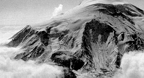
After extensive negotiation, we were finally allowed to make one flight, of course restricted to air space outside the 20-km buffer zones. This meant we could photograph the west side of the mountain and see the promising north side only obliquely, from high altitude. Unfortunately, low-lying clouds covered the mountain below 13,000 feet, and the recent snowfall obscured much of what remained.
The photographs taken, however, are of excellent quality, and do provide insight into a few areas of interest. They were taken in such a way as to provide stereoscopic coverage of the areas photographed, allowing three-dimensional viewing. The photos have now been carefully studied, and sadly, no hints of the Ark have been seen.
We are now involved in ongoing discussions with officials of the Turkish government and private parties, including an attempt to understand fully the scenario that kept us from realizing our research goals this past summer, and inquiries into the best way to proceed from here. We are even now exploring a way to achieve these same goals with minimal involvement from non-Turks, among other things.
Even though we didn't do all we had hoped to do, in the final analysis, we were able to secure governmental permission for an aerial--an answer to a 16-year prayer of mine. We now know much more of the implementation process and of Turkish law bearing on this issue, and know the ways to eliminate the specific problems which stymied us. Now is hardly the time to quit! The mechanism is in place and relationships established which might yield a proper survey next August.
Some positive results from this summer's work can be reported. Two new eyewitnesses were located--local residents who separately claim to have seen the Ark within the past few years. Both were interviewed, and are willing to take explorers to the site once permission can be obtained. Their accounts are not sufficient to stand alone, but coupled with all other data previously gathered, they add credence to the search.
Also, EO filmed extensive interviews with me on the foothills of Mt. Ararat, discussing the nature of the Flood and the search for the Ark. Questions like, "Where did the water of the Flood come from?" "Where did it go?" "How could Noah get all the animals on board the Ark?" "How could he care for the animals?" etc., were answered. It is hoped that these interviews will result in a popular teaching video in the months ahead.
Meanwhile, efforts are continuing to evaluate recent high-resolution satellite imagery of Mt. Ararat. Computer enhancement technique, developed for the data from the French "SPOT" satellite, makes it possible to "see" objects as little as three meters in diameter. ICR is committed to this study, and is involved in two such efforts.
As you may know, scores of individuals and groups applied for Ararat permits this past summer. In many Turkish government offices, the whole search has become a joke. Many of the applicants have no credibility, no experience, no workable plan, have done no preparation, and seemingly have no reasonable chance for success. Many claim divine guidance and knowledge of the whereabouts of the Ark. Nearly all, having no understanding of, nor regard for Turkish customs, regularly offend all they meet. Thankfully, our scientific and well-structured effort has been recognized by most officials, but the ill-will created by other groups spills over. The point is this: Since all groups raise money from Christians, I would encourage you to investigate and invest your money carefully.
The evidence continues to mount that the Lord has protected the Ark over the years since the Flood. In spite of the volcanic eruptions, the earthquakes, the erosion of the glacier, and the effects of time, the data strongly assert that the remains of the Ark lie somewhere on Mt. Ararat, buried by volcanic debris and ice, awaiting the proper time. God answers prayer, and we can be thankful for the progress made this summer. In His time and to His glory, the obstacles will be overcome and the Ark will be found. Even though the disappointment of this last summer is still fresh, I am convinced the discovery is near.
* Dr. John D. Morris (Ph.D. in Geological Engineering, University of Oklahoma) is President of the Institute for Creation Research.