Most of the fossil-bearing strata on Earth are comprised of six megasequences.1,2 Secular scientists believe they were laid down over millions of years, but this assumption prevents them from describing some prominent geological features—features that are best explained by large-scale flooding. Using data from over 500 stratigraphic columns,3 I examined megasequences across North America to document the sedimentary evidence for the Flood’s catastrophe. At each site, the megasequence boundaries were identified, along with the thicknesses and extent of individual rock types. These findings enabled the creation of computer maps that will build a chapter-by-chapter model of how the Flood changed the entire surface of the world.
Preliminary results demonstrate the presence of a seventh megasequence below the six common fossil-bearing megasequences. It lies just below the Sauk Megasequence in what secularists call the late Precambrian or Proterozoic Era. However, this newly delineated pre-Sauk sequence may be instrumental in documenting the onset of the Flood.
In part, the pre-Sauk megasequence was created by a tremendous outpouring of basaltic lava that split open central North America and caused the Midcontinent Rift.4 This fracture extended over 1,800 miles across what is now Lake Superior all the way to Kansas. It produced nearly 500,000 cubic miles of lava!4 The mystery of why it “failed” to grow into a large ocean like the Atlantic baffles secular scientists. And yet the Midcontinent Rift contains far more than lava flows—over 11 billion pounds of copper were mined from the Rift in Michigan’s upper Peninsula alone.5 Tremendous volumes of superheated groundwater—~430ºF (220ºC)—followed the eruption of lava and placed the huge copper deposits within the flows.5 Could this be evidence of the breaking up of the “fountains of the great deep” mentioned in Genesis 7:11?
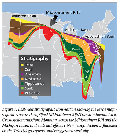 This research also demonstrates the Rift played a primary role in the formation of North America during the Flood year. Flood deposition for the next six megasequences had to detour around this uplifted area, as demonstrated by the thickening of the megasequences on either side of the Rift (Figure 1).
The Midcontinent Rift runs along the Transcontinental Arch—the high grounds of the Sauk, Tippecanoe, and Kaskaskia Megasequences combined.6,7 Uniformitarian geologists claim the Rift occurred 1.1 billion years ago, whereas the Arch formed 500 million years ago.4,6 Because of this 600 million-year difference, they cannot connect the two. And rocks representing this supposed time gap are also largely missing across most of North America, making the explanation even more problematic.
Furthermore, secular scientists cannot explain the formation of large basins adjacent to the rift zone, areas where the crust fell thousands of feet. However, the fountains-of-the-deep Flood model offers a solution. Rapid expulsion of nearly 500,000 cubic miles of magma and volumes of superheated water from deep in the earth would have created huge voids, possibly causing the crust below the basins to collapse.
The coincidence of the Midcontinent Rift, Transcontinental Arch, and the formation of adjacent, down-dropped basins makes sense in a biblical worldview. The Flood offers a connection between three seemingly disconnected events and better explains the Rift volcanism, and the burst of hydrothermal water can easily be understood as part of the “fountains of the great deep,” creating vast copper deposits. The Flood model also offers a cause for the drop of the crust beneath the sedimentary basins near the Rift—magma and water were expelled from underneath them, creating large sinkhole-like structures.
When the shackles of deep time are removed and Genesis is viewed as history, unrelated events start to fall into place.
References
- Megasequences are discrete groups of sedimentary rock layers bounded top and bottom by erosional surfaces, often with coarse sandstone layers at the bottom (deposited first), followed by shale, and then limestone at the top (deposited last).
- Morris, J. D. 2012. The Global Flood: Unlocking Earth’s Geologic History. Dallas, TX: Institute for Creation Research.
- A stratigraphic column is the record of which sediments are present at a particular location. It is compiled from the actual rock layers drilled through by a well and/or observed directly in outcrop.
- Marshall, J. 2013. North America’s broken heart. Nature. 504 (7478): 24-26.
- Bornhorst, T. J. and L. D. Lankton. 2009. Copper Mining: A Billion Years of Geologic and Human History. In Michigan Geography and Geology. Schaetzl R., J. Darden, and D. Brandt, eds. New York: Pearson Custom Publishing.
- Wicander, R. and J. S. Monroe. 2010. Historical Geology: Evolution of Earth and Life Through Time, 6th ed. Belmont, CA: Brooks/Cole.
- Hemmesch, N. T. et al. 2014. A sequence-stratigraphic framework for the Upper Devonian Woodford Shale, Permian Basin, west Texas. AAPG Bulletin. 98 (1): 23-47.
* Dr. Clarey is Research Associate at the Institute for Creation Research and received his Ph.D. in geology from Western Michigan University.